


scallipus
-
Posts
50 -
Joined
-
Last visited
Content Type
Profiles
Forums
Store
Articles
A20 Bugs
A21 Bugs
Events
Posts posted by scallipus
-
-
On 7/10/2021 at 5:39 AM, Lsjreadingpa said:
How do i give Kingen permission?
put kinggen in your users home directory and run it from there
if on windows (assuming a default install) copy kinggen.exe to the c:\users\<yourusernamegoeshere>\
MAKE SURE YOU REPLACE <yourusernamegoeshere> with the user name you log into the pc with and without the <> brackets!!!
Then run it from that directory as that user and it will work fine
0 -
On 7/5/2021 at 8:40 AM, Father said:
ummm that's downloading from my server to client
increase your servers setting for the players available bandwidth (helps a lot for decreasing map download times)... I set mine to a conservative 1Mbits a second which is 2 or 4x default settings... You could try setting it to 2048 (2 Mbits) and see how it goes
0 -
2 hours ago, Father said:
community maps sorry but i think i figured out what was wrong , it seems snow level went from 0 to 1 just reset settings hopefully it will come out right
just hope this generator don't leave mosses parting the red sea areas in the water like nitrogen does
The moses effect in nitrogen literally cost me days and days of testing custom height maps and regenerating and putting onto the test server etc... King Gen overall does not produce the anomolies that nitrogen did that saw long runs of thin land strips going to the edge of the world in the middle of the ocean
0 -
On 6/27/2021 at 1:27 AM, KingSlayerGM said:
The cumminity heightmap download feature is ready for its first release
")
I still want to try to improve generation of roads though. I think I can release KG11 tomorrow night
@scallipus what's the optimal water level for the hm you submitted? It doesn't see to be the default 43...
@KingSlayerGM
I used 45 I think for the water level
Here is the contents of the settings fileSpoilerSETTINGS:
biomes_map=E:/Users/Lloyd/KingGen/scallisworld_biomes.png
border_size=medium
border_type=water
burnt_size=medium
cities_grid_size=large
cities_level=60
cities_map=E:/Users/Lloyd/KingGen/aussie_base_8K_rgb8_poi_placement - Copy.png
cities_number=lots
cities_size=large
default_biome=pine forest
default_biome_tools=pine forest
desert_size=medium
heightmap=E:/Users/Lloyd/KingGen/aussie_base_8K_gb8_lev5.55.png
heightmap_smoothing=none
mountains_size=medium
multiple_generations=1
name=ScallisWorld
output_folder=
png_heightmap=no
pois_list=vanilla
pois_number=increased
seed=ZjrQbZBqSx
size=8
skip_preview=false
snow_level=
snow_size=medium
spacing=medium
spawn_points=medium
terrain_roughness=medium
towns_grid_size=large
towns_number=lots
towns_size=large
traders_location=cities
traders_number=increased
villages_grid_size=large
villages_number=lots
villages_size=large
waste_size=medium
water_level=45
water_size=medium
zoning_map=E:/Users/Lloyd/KingGen/poi_city_zoning2.pngan interesting thing happened when I started using custom water maps in KG 10... will test KG 11 with the same artwork tomorrow and report back
There was artifacting along the waters edges in some places (no water was being placed), but you will be pleased to know that when I did a custom height map for just the water and eroded the terrain map to suit, the water for the custom river worked really well (although it did change height levels as the water area tested was done using the original terrain map downsampled to 8bit GS as required by KG for water maps if I am not mistaken, and the terrain was eroded so the water had depth
Overall a good first go at custom water, there was no anomolies on the ocean apart from what actually appears to be a result of the selection tool edging used in gimp0 -
On 6/27/2021 at 5:43 AM, Gouki said:
Hi Scallipus
Thank you very much for this wonderful tool, I have created only 1 biome map, because it is a bit difficult for me when I am painting the biomes and adjusting the zoom in the window that opens when you create a new biome map.
The window does not show you the entire biome map like Gimp, Paint or Photoshop does.
I think it would be a good idea to adjust that, don't you think.
At first I could not run the program due to the lack of a DLL (vcruntime140_1), but that has already been solved, nothing serious.
RegardsHi, yes zooming the window is something I am working on
") , I am also working on it indicating to the user what the current brush and selected colour are along with the brush parameters
, I am also working on it indicating to the user what the current brush and selected colour are along with the brush parameters
Umm the program uses static linked libraries so I am unsure why it is asking for the vcruntime but it is entirely possible something VS is doing behind the scenes requires it. Glad you sorted it out
0 -
14 hours ago, MichaelL. said:
What are the dark brown and grey areas?
burnt and wasteland biomes
11 hours ago, KingSlayerGM said:I am working on an update to address this. It will probably be in KG 12.
you could also try adding downtown zoning that might put more sky scrapers in that area?
0 -
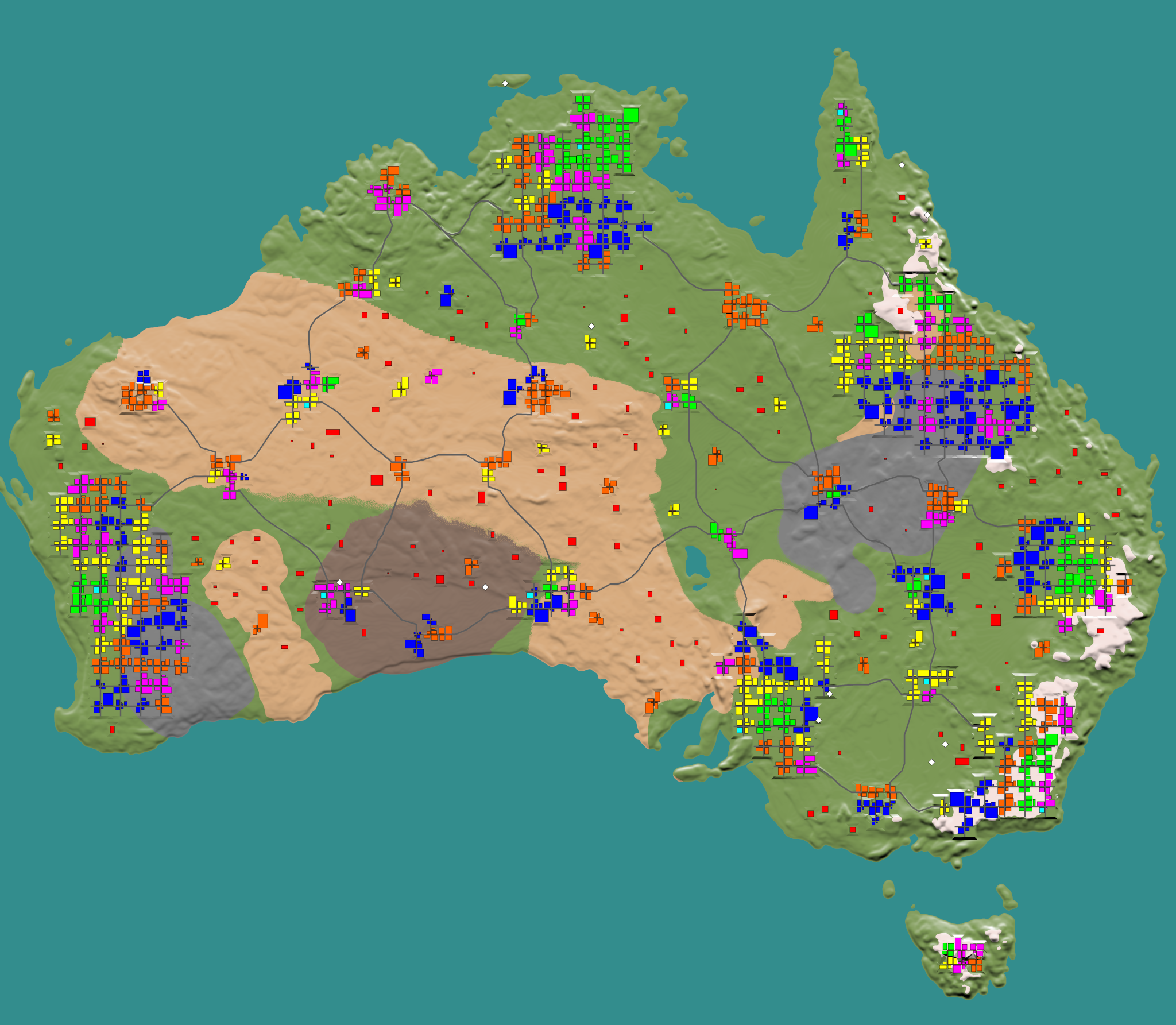
Today I released a community map for King Gen, its based on the Australian Digital Elevation Map data set.
I have put a completed world up on my scallisgaming wbsite for download.
Here is the direct download link to the world archive
https://scallisgaming.com/ScallisAussieMap.7zIt's a 7zip archive and to use it, unpack it and copy the directory that unpacks to your 7 days to die GeneratedWorlds folder and start a new game
It uses vanilla poi's (inb4uask)
Feel free to use the map however you like, It's for you - The 7 Days To Die Community to play with
And here is a preview of the map

2 -
Had a Lysdexic moment, had a couple of colours slighly wrong... all fixed now
0 -
thanks
I like C and C++ have been a novice hobby programmer for a few years but it's also been many years since I last coded anything
wxWidgets was a huge help for the GUI as I did want it to be cross platform - it should compile under linux as well as there are no special windows specific calls being made from my code...
Just use wxWidgets 3.15 for compiling itAlso just to be clear because I did not include a licence file of any sort - the source code for my little editor project is free to use for anyone for any reason consider it public domain.
0 -
5 hours ago, DJQuad said:
Thanks! I got the pack. It doesn't look like there's anything related to the canyon so I'll ask them. Do you know if there's a heightmap for Navezgane?
There is a heightmap its the dta.raw file in the navezgane world folder
If I am not mistaken king gen can import that raw file???0 -
No probs will do @KingSlayerGM
Also so you know, I just finished the first public release of my biome editing tool earlier today and have included palettes for the current selection of biomes, kinggens city / town / villiage and no poi regions as well as a palette for the zones.
I will work on allowing having the heightmap as a background image layer to help with making the poi placement and zoning maps and will look at wether or not its possible to add a water map editor to it as well.
I've posted the links to the biome editor and the c++ source code for it in separate tools thread1 -
I was looking for a different solution to gimp and photoshop for editing biome.png files for 7 days to die...
I decided to write an editor for it and it can also be used to create some of the additional mapping files that KINGGEN can use with the included colour palettes...
Feel free to check it out and don't forget to report any bugs you find here.
Cheers.
Both the stand alone editor and the source code are available at the following url's
https://scallisgaming.com/Biome_Editor.7z
https://scallisgaming.com/Biome_Editor_Source_Code.7z2 -
A couple of custom maps are incoming @KingSlayerGM I will PM you with some D/L Details once they are on my webserver and you can grab em and place em with the community maps
0 -
On 5/21/2021 at 1:11 PM, KingSlayerGM said:
Now that both 8 and 16 bit png heightmaps are supported, which one will you use?
I am currently using 16 bit height maps in my test worlds I am using kinggen for generating, I was working with 8 bit heightmaps in nitrogen because that was what it was seeming to work the best with (reduced image anomolies)
Ultimately I think I would use 16 bit height maps as a preference to 8 bit
I have done a number of tests with KingGen and it appears to NOT introduce the water anomolies that were bugging me with nitrogen which is a really good thing.
For the last week and a half I have been tooling around behind the scenes working on a custom world editor of sorts that hopefully will complement your great tool by allowing me to further tweak the worlds generated by kinggen.
1 -
On 5/21/2021 at 5:43 PM, KingSlayerGM said:
@scallipus I am considering the idea of having a small group of handmade heightmaps bundled with KingGen. So that people can choose with a drop down list if they want to use any of them for the generation. It would be a nice little feature for people that don't know how to make their own custom heightmaps.
I am thinking of asking a few expert map makers if they would like to share one or two heightmaps for this purpose. Their names would be included with the maps. Would you be interested?
I thought about it, it could be nice. Also some vanilla pois are caves.
I also thought about having a bunch of sewage pois and subway pois and placing them underneath cities to create intricate underground grids. I could be nice...
I sure would be fine with making a custom height map or two for this project which you can then distribute as you like
Is there a particular size map you were looking for?
0 -
So far its working great under Win 10 will test it under linux desktop on the weeken@KingSlayerGM
0 -
4 hours ago, Spiritz said:
I have a small request and i dont know if already suggested ( not checked all the posts ) but when a map is generated is it possible to also have the preview saved . When generating multiple maps i would like to be able to easily compare the poi`s . On a different note , Bro this program is a godsend and easy to use so i must say a Big TY
That is already done the preview is saved in each world directory generated so you can compare them using your favorite image viewer
0 -
33 minutes ago, gpcstargate said:
Good Day ALL
DO we Know if anyone is planning to Take over this Great Software to keep it going .. Such a great piece of work that needs to be maintained by someone of knowledge that can keep it great.
Just Wondering and Thank You
@gpcstargateI would say check out KingGen, that is making some rapid ground in the map making area.... It is working reasonably nicely so far and @adrian KingGen also supports biome specific buildings.
It is also very fast, probably faster than Nitrogen by about a factor3 -
is it possible to allow us to define POI 'limits' for the decreased, medium and increased settings or is it possible to allow us to have a setting that lets us define the total number of poi's we want in the world? The reason I ask, 10K maps get a bit sparse even on increased settings or perhaps another couple increased settings levels that allow us to have even more poi's in the world if we want them - you might even name lots more and max
 0
0 -
1 hour ago, KingSlayerGM said:
Cities generate at y 60. So consider having you flat terrain around that level
no problem I have worked out a workflow that will allow me to fix the issue I was facing with the hard ramps
Keep up the great work...
This is the result of the workflow change I have made for using KingGen as a map generator.
going from this
https://steamcommunity.com/sharedfiles/filedetails/?id=2485007089
and taking it to this
https://steamcommunity.com/sharedfiles/filedetails/?id=2485006988
1 -
in this picture I added some noise to a small strip along one part of the edge of the citys raised land area and then did a gaussian blur using a 10 x 10 pixel size block along the edge of the city block where the noise was place.
https://steamcommunity.com/sharedfiles/filedetails/?id=2484913209
In this picture I turned 180 degrees and it shows your current setup for the land ramping up to the city level.
https://steamcommunity.com/sharedfiles/filedetails/?id=2484912444
Here is an areal picture looking down...
https://steamcommunity.com/sharedfiles/filedetails/?id=2484913070now this was with some very minimal noise added and it was level dampened considrably so it's not a pronounced impact but needless to say there is some roughness and variation to the ramp up, and the strip initially chosen was quite narrow as I was not sure how wide in gimp to modify the city block area as I did not want to risk making it so there would be issues for the poi itself. but needless i'll investigate this some ore and see if I can come up with either a gimp filter or even a stand alone program to identify the city areas and feather out the ramps with some noise and blur to help make it more natural feeling terrain
It might be more apparent in the map view
this is a section of the map in the desert,
https://steamcommunity.com/sharedfiles/filedetails/?id=2484941952
And a section I did the same as I mentioned above only I spread it out over a little bit more of an area
https://steamcommunity.com/sharedfiles/filedetails/?id=24849421401 -
https://steamcommunity.com/sharedfiles/filedetails/?id=2484887919
https://steamcommunity.com/sharedfiles/filedetails/?id=2484887882
there are a couple of areas highlighting the issue, I am working on my own solution at the moment to the issue which would be a separate tool to run the DTM through after generation...
It seems for the most part all your cities share the same height on the map regardless of the surrounding area - at least on the aussie map I am working on your city foot prints in the dtm.raw file all return the same colour level it seems so the work around I am thinking about doing is a tool to add noise variations between the city level layer and the surrounding terrain it is connecting to.0 -
Its up again it was not set for autorestart after daily server reboot
0 -
Improvements for the dedicated server
in Tools
Posted
@Alloc Is there a way you are aware of to solve a webmap issue I am having?
I run a few servers, each with their own webmap and port etc, now the web maps for each server used to be able to be viewed until I went over to ssl security for my site. Now for whatever reason the map will not show up when it's used on a https: all port connections go to the right machines - the web ports for each server are different and the router is forwarding to the correct machines for the given web ports...
Any ideas as to why this might be happening or any hints on how I could get the page to 'link' and display from within my apache 2 webserver which runs on another machine?